Introducing WingX V9
WingX V9 supports an extraordinary moving map with advanced features geared towards the safety of the pilot and aircraft and the success and safety of a flight. Download V9 today from the Apple store.
VFR Sectionals
Can be zoomed and pinched, they are seamless across the whole US. But that's not all, WingX can display terrain that's above you - will you get over that ridge?

IFR Low/High Charts
IFR Low/High Enroute Charts can be zoomed and pinched, they are seamless across the whole US.
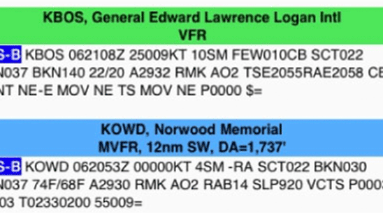
ADS-B METARs, TAFs…
ADS-B Weather and Traffic, NOTAMs, PIREPs, and AIRMETs appear right on the moving map page. Don't be surprised when you get your destination and the weather isn't what you had expected or perhaps a runway was closed. Get the latest AIRMETs and PIREPs for your flight and know the unexpected.
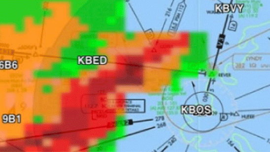
ADS-B NEXRAD
Seamlessly overlaid on Sectionals, or IFR Enroute charts. This real-time in-flight weather information is an amazing addition to the moving map. Of course, moving map screens with ADS-B NEXRAD can be pinched, zoomed and panned.
Geo-Referenced Charts
Geo-Referenced Approach Charts fit seamlessly into the moving map. WingX uses our own comprehensive and accurate geo-referencing data for the most accurate aircraft positioning possible. When you are getting vectoring around in the muck, wouldn't you like to know exactly where you are? The Advanced IFR options includes IAP geo-referencing and our IAP Routing capability.
TFRs
TFRs (Temporary Flight Restrictions) displayed right on the Moving Map. So are Special Use Airspaces (SUA) - and you simply tap on them to get the altitudes, effective dates and times, frequencies and other pertinent information - isn't this better then trying to find all that small print on your sectional listing this info?
Dual Moving Maps
Enables you to monitor your flight as if you have two moving map devices. How cool is that? You can display a sectional and an IFR enroute, or two sectional with one zoomed in and one zoomed out, or an IFR enroute and a geo-referenced approach chart.
Fuel Prices
Fuel Prices are stored on your device and can easily and quickly be reviewed in flight with no Internet connection. WingX does all the work for you by finding the cheapest fuel prices and sorting them in order of prices based on your distance from an airport or other point on the moving map.
WingX is an advanced mobile aviation app with the widest and most sophisticated feature sets including its unique technologies such as WingX Rewind™, FlightShare™, SmartTaxi™ and traca™.
WingX Pricing
Base $74.99
Advanced IFR $74.99
Synthetic Vision FREE
Fuel FREE
WingX Refund Policy:
WingX subscriptions are tied to your app store purchase. All refund requests must be submitted directly through the Google Play Store, Amazon App store, or Apple App store dependent upon which was originally used to purchase WingX. Refund requests are subject to eligibility requirements as defined by the Google Play Store, Amazon App Store, and/or Apple App Store.
WingX subscriptions are otherwise non-refundable. We do offer a one-time only, 30 day free trial to all users in order to ensure that customers have the opportunity to evaluate WingX completely prior to purchasing.


Weather Data
Interactive weather features by Baron Velocity Weather
AFSS
Integrates seamlessly with FAA's Flight Service Station
Support Team
Dedicated support team with real people and real pilots